
On November 15, 2023, Mayor Eric Adams, New York City Economic Development Corporation President and CEO Andrew Kimball and Mayor’s Office of Media and Entertainment Commissioner Pat Kaufman joined East End Studios to celebrate the groundbreaking of a new film and television production studio in Sunnyside, Queens.
NYCEDC
NYCEDC Announces Community Outreach Phase of Hunts Point Redevelopment Plan

The New York City Economic Development Corporation (NYCEDC) selected a team at the Pratt Center for Community Development to facilitate community outreach for a plan to redevelop Hunts Point. Starting this spring, NYCEDC and the Pratt Center for Community Development will host public workshops and meetings for the Hunts Point community as part of its engagement plan. Over the next 18 months, residents and businesses will share their opinions on the current state of Hunts … <Read More>
Plans for Broadway Junction’s Transformation and Revitalization are Revealed

The Vision Document represents the first effort by the City and the Brooklyn community to solely focus on Broadway Junction. On August 15, 2019, Council Member Rafael L. Espinal, Brooklyn Borough President Eric L. Adams, and the New York City Economic Development Corporation (NYCEDC) commissioned a Vision Document, Broadway Junction: Vision for the Future that serves as a guide to supporting the transformation of Broadway Junction in Brooklyn. The Vision Document is the first step … <Read More>
City Council Subcommittee and Land Use Committee Vote to Approve the Rezoning of Water Street’s Privately Owned Public Space With Modifications

The modified version requires a full public review process in order to infill the largest arcades covered by the proposed zoning text amendment. On June 15, 2016, the City Council Committee on Land Use voted unanimously to approve a modified version of an application submitted by the Alliance for Downtown New York, the NYC Economic Development Corporation, and the Department of City Planning to rezone the privately owned public space—colloquially known as “POPS”—on and surrounding … <Read More>
City Council Subcommittee Hears Testimony on the Rezoning of Water Street’s Privately Owned Public Space
Council Members voiced concerns over the proposal’s provisions stripping the City Council of its review over future applications brought pursuant to the proposal. On May 4, 2016, the City Council Subcommittee on Zoning and Franchises held a public hearing on an application submitted by the Alliance for Downtown New York, the NYC Economic Development Corporation, and the Department of City Planning to amend the zoning text controlling the Water Street corridor in lower Manhattan. For … <Read More>
City Planning Commission Hears Testimony on Proposed Greater JFK Industrial BID
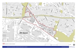
The proposed IBID’s geographic boundaries do not include the JFK airport itself, which ensures it would serve the needs of the surrounding off-airport community. On April 13, 2016, the City Planning Commission held a public hearing on the New York City Department of Small Business Services’ application to create the Greater JFK Industrial Business Improvement District, or IBID, located in Springfield Gardens, Queens. Though the proposed IBID would be the largest IBID in the City, … <Read More>