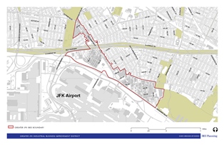
The proposed IBID’s geographic boundaries do not include the JFK airport itself, which ensures it would serve the needs of the surrounding off-airport community. On April 13, 2016, the City Planning Commission held a public hearing on the New York City Department of Small Business Services’ application to create the Greater JFK Industrial Business Improvement District, or IBID, located in Springfield Gardens, Queens. Though the proposed IBID would be the largest IBID in the City, … <Read More>
Queens Community Board 12
Variances Granted For Church-Owned Mixed-Use Facility

Board granted the variances despite divided community support. On September 23, 2014, the Board of Standards and Appeals voted to grant five variances to St. Albans Presbyterian Church for the construction of a five-story mixed-use facility at 118-27 Farmers Boulevard. The development site is located in St. Albans, Queens, and bounded by Farmers Boulevard to the west, 119th Avenue to the south, 189th Street to the east, and 118th Avenue to the north. The facility … <Read More>
Council approves St. Albans & Hollis rezoning
Downzoning will preserve residential character. On October 29, 2007, the City Council approved, with modifications, City Planning’s plan to rezone 317 blocks in the St. Albans and Hollis sections of Queens.
The plan, the result of a collaborative effort between Queens Community Board 12, Council Member Leroy Comrie, and City Planning, seeks to protect the area after market pressures forced some owners to sub-divide their lots or tear down existing one- and two-family homes in … <Read More>
Jamaica rezoning approved with modifications

- The Jamaica Plan: Proposed Zoning with City Council Modifications, subject to adoption by the City Council by September 19, 2007, used with permission of the New York City Department of City Planning. All rights reserved.

Largest rezoning undertaken by City sent back to Commission for final approval. The City Council approved, with several significant modifications, the Planning Commission’s proposal to rezone 378 blocks in Jamaica, Queens. The Council’s modifications must now go to the Planning … <Read More>
Council down-zones 68 blocks in Queens
Springfield Gardens residents petitioned City to initiate down-zoning. On April 12, 2005, the City Council down-zoned 68 blocks of Springfield Gardens, Queens, completing a three-year process initiated by a local community group, the United Neighbors Civic Association.
Concerned about the proliferation of multi-family apartment buildings replacing small, single-family homes, members of United Neighbors canvassed Springfield Gardens with a petition requesting that the City down-zone the neighborhood to hinder future demolition. Acting on the request, the … <Read More>