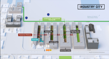
Despite two years of discussion, Industry City ownership unable to convince Council Member Menchaca and Community Board 7 to support expansion. On February 19, 2020, the City Planning Commission held a public hearing on an application for four land use actions to expand bulk and use requirements for Industry City, in Sunset Park, Brooklyn. Industry City is a 5.3 million square feet mixed-use complex comprised of sixteen buildings with commercial, manufacturing, and community facility uses. … <Read More>
Brooklyn Community Board 7
Proposed Development Would Bring MIH to Windsor Terrace
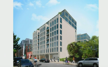
City Council member raises concerns about effects of rezoning on adjacent stables. On September 5, 2018, the City Council Subcommittee on Zoning and Franchises held a hearing on an application by developer, 57 Caton Partners, LLC, to rezone 57 Caton Place in the Windsor Terrace neighborhood of Brooklyn. The developer is requesting a zoning map amendment and zoning text amendments to facilitate the development of a new nine-story, mixed-use building.
Local Preservationist Group Builds Support for Neighborhood Designation
![]() Grassroots campaign takes to the streets to build community support to preserve rowhouses from out-of-character development. On Saturday, June 1, 2013, the Sunset Park Landmarks Committee (SPLC) sponsored its third walking tour of Sunset Park, Brooklyn. The tour, which begins on 43rd Street and 4th Avenue and concludes on 8th Avenue and 60th Street, is one of the committee’s ways to gain support for the creation of a historic district in Sunset Park by the … <Read More>
Grassroots campaign takes to the streets to build community support to preserve rowhouses from out-of-character development. On Saturday, June 1, 2013, the Sunset Park Landmarks Committee (SPLC) sponsored its third walking tour of Sunset Park, Brooklyn. The tour, which begins on 43rd Street and 4th Avenue and concludes on 8th Avenue and 60th Street, is one of the committee’s ways to gain support for the creation of a historic district in Sunset Park by the … <Read More>
Sunset Park 197-a plan OK’d
The City Planning Commission had refused recommendation to relocate sanitation garage on the 52nd Street Pier. On December 21, 2009, the City Council approved Brooklyn Community Board 7’s comprehensive plan to improve the Sunset Park waterfront, known as “New Connections/ New Opportunities – Sunset Park 197-a Plan.” The waterfront is zoned primarily for manufacturing uses and fell into disrepair in the 1960s and 1970s. The City owns most of the waterfront property.
CB7 began the … <Read More>
Sunset Park Community Board’s 197-a Plan heard
Community board puts forward its own plan to revitalize industrial waterfront. On October 7, 2009, the City Planning Commission heard testimony on Brooklyn Community Board 7’s plan to revitalize the Sunset Park waterfront. The plan is permitted under section 197-a of the City Charter, which authorizes community boards to propose a framework for future development in their districts. CB7 developed the comprehensive proposal over a thirteen-year period with input from local residents, businesses, and civic … <Read More>
Rezoning and inclusionary housing approved
South Park Slope rezoned to protect low-rise character and provide affordable housing. On November 16, 2005, the City Council rezoned 50 blocks of South Park Slope and applied the inclusionary housing program to specific R8A districts along Fourth Avenue, allowing an increase in a building’s floor area with the developers’ commitment to build affordable housing on or off site. The proposal called for the rezoning of an area generally bounded by 15th Street on the … <Read More>