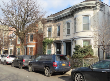
The houses within the proposed historic district have a consistent architectural style and retain most historical details from the early 20th century. On January 21, 2020, the Landmarks Preservation Commission voted to calendar a proposed historic district in Hunts Point, Bronx. The Manida Street Historic District would be located on Manida Street between Garrison and Lafayette Avenues and would consist of 42 semi-detached, two-story brick houses on both sides of the street. The district would … <Read More>
historic district
Approval of Alteration – UPDATE: Case on Appeal
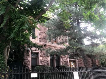
The owners of the Dean Sage Mansion in Crown Heights North Historic District sought to build addition to the 1870’s mansion. In the mid-nineteenth century the Crown Heights neighborhood of Brooklyn underwent suburban development of freestanding villas. Today, only a few of the Sturgis villas remain, one of which is the Dean Sage Mansion at 839 St. Mark’s Avenue, a rare High Gothic style mansion built in 1870 by architect Russell Sturgis. The Mansion, which … <Read More>
Landmarks Designates Bay Ridge’s First Historic District
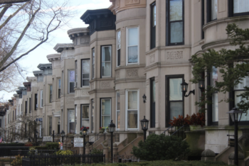
The 100-year-old block stands out in the neighborhood for its high architectural quality and aesthetic consistency. On June 25, 2019, the Landmarks Preservation Commission voted to designate Bay Ridge’s first historic district, “Bay Ridge Parkway – Doctor’s Row.” The new historic district is comprised of 54 two-story and basement rowhouses located on a prominent 100-foot wide, tree-lined block along Bay Ridge Parkway between 4th and 5th Avenues in Brooklyn. The rowhouses were all … <Read More>
DUMBO Historic District Commemorates New District Marker

Marker celebrates importance of manufacturing history of the district. On August 24, 2018, the Landmarks Preservation Commission, the New York Landmarks Preservation Foundation, and the DUMBO Neighborhood Alliance, announced a historic district marker to promote and commemorate the 2007 designation of the DUMBO (Down Under the Manhattan Bridge Overpass) Historic District. The marker is located mid-block on Jay Street, between Water and Plymouth Streets, highlighting the boundaries of the district and its historic importance. To … <Read More>
Testimony in Support and Opposition to Historic District Extension Heard from Community Members

Controversy focused on small section of Atlantic Avenue commercial corridor proposed for inclusion in district extension, characterized by 19th-century low-rise buildings. Landmarks held a hearing on the designation of the Boerum Hill Historic District Extension on May 8, 2018. The extension would be composed of three direct sections adjoining the existing Boerum Hill Historic District to the north, south, and west. Approximately 288 buildings are included in the proposed extension, roughly equal in … <Read More>
Landmarks Hears Mixed Testimony on Proposed East Village/Lower East Side Historic District
New district would encompass more than 300 buildings in an area that was home to successive waves of immigrant groups. On June 26, 2012, Landmarks heard extensive testimony on the proposed designation of the East Village/Lower East Side Historic District. The proposed district would encompass approximately 330 buildings located primarily along Second Avenue between St. Marks Place and East 2nd Street and adjacent side streets. A portion of the district would extend along … <Read More>