
On November 2, 2023, Mayor Eric Adams and Department of City Planning Director Dan Garodnick celebrated the City Council passage of the South Richmond Zoning Relief plan. The relief plan will simplify zoning procedures for homeowners in the Special South Richmond Development District on Staten Island.
Staten Island
$75 Million Enhancement of Staten Island Bluebelt Underway
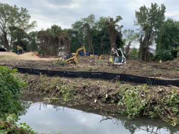
Bluebelts improve the health of local waterways and increase nearby property values by managing stormwater and reducing flooding while protecting natural spaces. On October 1, 2020, New York City Department of Environmental Protection Commissioner Vincent Sapienza, Department of Transportation Commissioner Polly Trottenberg, and Department of Design and Construction Commissioner Lorraine Grillo announced that construction began on a $75 million enhancement of the Bluebelt program in the Mid-Island area of Staten Island.
City Planning Proposes Homeowner-Friendly Zoning Rules for Staten Island Neighborhoods

The changes allow homeowners to bypass the lengthy review process for certain types of projects. On July 2, 2020, the Department of City Planning announced new proposed zoning rules for some Staten Island neighborhoods that make zoning rules more efficient and homeowner-friendly, and that reflect recent advances in environmental science.
Upgraded Storm Sewers to be Installed in Richmond, Staten Island

The project aims to relieve street flooding in the neighborhood. On July 9, the NYC Department of Environmental Protection and the NYC Department of Design and Construction announced a $6 million project to upgrade storm sewer infrastructure in the neighborhood of Richmond, Staten Island. The project began in January 2020, and is scheduled to be completed during the summer of 2021.
Landmarks Approves Modified Plans for Kreischer House Senior Development
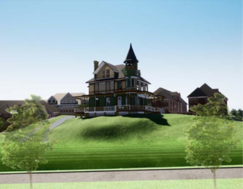
The modified design increased the visibility of the Kreischer Mansion on the site. On May 8, 2020, the Landmarks Preservation Commission voted to approve a Certificate of Appropriateness for three actions to facilitate the development of a new senior housing complex, comprising of eleven buildings, surrounding the Kreischer House. The Kreischer House, a two and a half story Victorian-era mansion, and a portion of the land it sits on is a landmarked site in Charleston, … <Read More>
Landmarks Holds Public Hearing for New Senior Housing Near Kreischer House

Landmarks expressed support for the proposed senior housing complex but raised some concerns regarding the new buildings’ impact on the Kreischer House site. On February 4, 2020, the Landmarks Preservation Commission held a public hearing on a Certificate of Appropriateness for three actions to facilitate the development of a new senior housing complex, comprised of eleven buildings, surrounding the Kreischer House. The Kreischer House is located at 4500 Arthur Kill Road in Charlestown, Staten Island. … <Read More>