logo CityLand
      • Home
      • About CityLand
      • CityLand Sponsors
      • Filings & Decisions
      • Commentary
      • Archive
      • Resources
      • CityLaw
      • Current Issue

    City Launches COVID-19 Cluster Map Amid Rise in Hotspots

    COVID-19  •  Citywide

    The “Find Your Zone” Map showing yellow, orange and red zones over several neighborhoods in Queens. Click to enlarge image. Image Credit: NYC Mayor’s Office/Office of Emergency Management

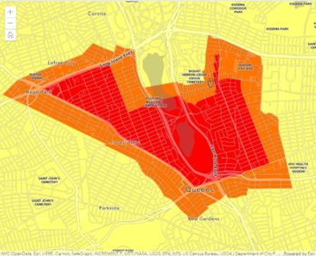
    Indicated zones will undergo restrictions for a minimum of 14 days after the zone is identified. On October 7, 2020, Mayor Bill de Blasio announced the launch of the ‘Find Your Zone’ map, the City’s newest tool to help New Yorkers stay informed about the spread of COVID-19. The map allows users to enter an address to identify if that location is in a COVID-19 hotspot and what restrictions may apply to that zone for local schools, businesses, houses of worship, and other gatherings. (read more…)

    Tags : businesses, coronavirus, COVID-19, indoor dining, Interactive Tools, non-essential businesses, outdoor dining, Schools
    Date:10/09/2020
    Category : Mayor
    (1) Comment

    Subscribe To Free Alerts

    In a Reader

    Desktop Reader Bloglines Google Live Netvibes Newsgator Yahoo! What's This?

    Follow Us on Social Media

    twitterfacebook

    Search

    Search by Category

      City Council
      CityLaw
      City Planning Commission
      Board of Standards & Appeals
      Landmarks Preservation Commission
      Economic Development Corporation
      Housing Preservation & Development
      Administrative Decisions
      Court Decisions
      Filings and Decisions
      CityLand Profiles

    Search by Date

    © 1997-2010 New York Law School | 185 West Broadway, New York, NY 10013 | 212.431.2100 | Privacy | Terms | Code of Conduct | DMCA | Policies