Image Credit: NYC Department of City Planning.
The Department of City Planning found that underserved communities do not have easy access to New York City’s waterfronts, and thus lose out on the benefits granted from waterfronts. On May 20, 2022, the Department of City Planning released a report and map detailing New Yorkers’ access to New York City waterfronts. The report, Assessing New Yorkers’ Access to Waterfronts, discussed the need for an increase in access to waterfronts, particularly for underserved communities. The map, Waterfront Access Map, noted the areas of publicly accessible waterfronts and allowed for viewers to interact with the map to determine bike, ferry, and subway transportation routes to the waterfronts.
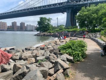
New York City has 520 miles of shoreline. Over the years, hundreds of different waterfront parks and open spaces were used for the recreation, relaxation, and reflection of New Yorkers. The waterfronts can be and are utilized for various purposes, all of which provide direct benefits for New Yorkers, including: exercising, boating, swimming, areas for relaxation and meditation, dog walking, biking, fishing, among many other benefits. By expanding access to open space along the shoreline, New Yorkers will have additional areas for recreational and relaxational purposes.
Unfortunately, not everyone has easy access to these waterfronts.
The report detailed that, of the 2.9 million New Yorkers living within a half-mile walk of the waterfront, over two million New Yorkers have a publicly accessible waterfront, amounting to approximately 70 percent of the people. The remaining 30 percent of the people, amounting to more than 800,000 New Yorkers, cannot easily access the waterpoint because they lack a waterfront public access point within a half-mile walk.
The vast majority of these 800,000 New Yorkers, come from communities that are less wealthy than those closer to the shoreline and from communities of color. These findings in the report and map released by the Department of City Planning further promotes and prompts the need for access to waterfronts to underserved communities. In this way, everyone can enjoy from the shared benefits that New York’s waterfronts have to offer.
The Department of City Planning’s goal in researching about and releasing a report and map on New Yorkers access to the City’s waterfronts was to make public access to the waterfronts more equitable, particularly for people from underserved communities. And the Department succeeded in doing so, by expanding public access in places such as the North Shore of Staten Island and the Bronx’s Harlem River waterfront.
There are also other waterfront parks that, while not well known outside of their neighborhood, are extremely important to the people living nearby, such as, Barretto Point Park in the Bronx and Valentino Pier Park in Brooklyn.
Department of City Planning Director, Dan Garodnick, stated, “Every New Yorker should be able to reach and enjoy our shoreline and experience all it has to offer… and [w]e can do even better.” With the report and map in hand, the communities in need for publicly accessible waterfronts can be easily identified and accommodated.
By: Malka Amar (Malka is a CityLaw intern and New York Law School student, Class of 2023.)
He Dan: How about adding some more floating pools for inaccessible communities?????