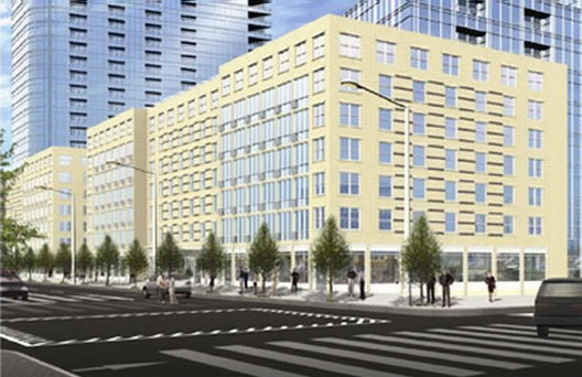
Rendering of 74 Wallabout Street courtesy of Magnusson Architecture and Planning PC.
Developer asked the City to rezone manufacturing-zoned block in order to develop a seven-story building and a five-story extension for an adjacent religious school. On September 12, 2012 the City Council approved 74 Wallabout LLC’s proposal to demolish a low-rise warehouse building and build a seven-story mixed-use building at 74 Wallabout Street in South Williamsburg, Brooklyn. The warehouse sits on the western half of a block bounded by Wallabout Street, and Flushing, Franklin, and Kent Avenues. The Pointe Plaza Hotel (a converted industrial building) and the K-12 Yeshiva Bnos Ahavas Israel occupy the block’s western half. The new building will be 70 feet tall and include 120 rental units, 28,439 sq.ft. of ground floor retail space, and 60 underground parking spaces. 74 Wallabout LLC plans to make the apartments affordable to moderate income households. 74 Wallabout LLC also plans to sell a 5,000-square-foot portion of its property to the yeshiva, and build the school a 17,640-square-foot, five-story rear extension. To develop the project, 74 Wallabout LLC requested that the block be rezoned from M1-2 to R7-1 with a C1-5 commercial overlay.
(more…)

Credit: Karl Fischer Architect
Developer plans to build two, eight-story buildings on Walton Street between Union and Marcy Avenues. On July 25, 2012, the City Planning Commission approved Walton Realty Associates’ proposal to develop a two-building residential project at 59 Walton Street in South Williamsburg. Walton Realty would demolish a low-rise storage and distribution facility on Walton Street between Union and Marcy Avenues and build two, eight-story buildings. The buildings would rise up to 80 feet and provide a total of 69 apartments, including 14 units of affordable housing.
To facilitate the development, Walton Realty requested that the City rezone three blocks bounded by Middleton Street and Union and Marcy Avenues. The northern block between Middleton and Lorimer Streets and Union and Marcy Avenues would be rezoned from M1-2 to R6A. The two southern blocks, which include the project site on Walton Street would be rezoned from M3-1 to R7A and R7A/C2-4. Walton Realty also requested that the City apply the inclusionary housing program to the R7A and R7A/C2-4 district on the block bounded by Lorimer and Walton Streets in order to use the inclusionary housing floor area ratio (FAR) bonus for the project.
(more…)
Neighbors objected to the size and materials of proposed one-family townhouse. On August 2, 2011, Landmarks approved Louis Greco’s revised proposal to build a new townhouse on a vacant lot at 27 Cranberry Street in the Brooklyn Heights Historic District. The vacant lot is on the north side of Cranberry Street between Hicks and Willow Streets. The block is characterized by three- and four-story rowhouses developed in the late 1800s.
On June 7, 2011, Greco’s architect, Tom van den Bout, presented the proposal’s initial design. The plan called for a three-and-ahalf- story building with a setback penthouse. Van den Bout planned to clad the building’s front facade in Portland brownstone with brick on the side and rear facades. The penthouse’s facade would be clad in bronze, and according to van den Bout, only be visible from oblique angles. The building’s cornice would be higher than the adjacent buildings and also clad in bronze. The second and third floors would feature three window bays, while the first floor would include an oversized projecting window bay to help avoid the perception of squatness. (more…)

- Proposed Crown Heights North II Historic District. Image: Courtesy LPC.

- Proposed Crown Heights North III Historic District. Image: Courtesy LPC.
New district would comprise more than 600 buildings south of original Crown Heights North Historic District. On June 28, 2011, Landmarks voted to designate the Crown Heights North II Historic District in the northwest section of Crown Heights, Brooklyn. The residential district includes more than 600 buildings generally bounded by Bergen Street to the north, Eastern Parkway to the south, Brooklyn Avenue to the east, and Nostrand Avenue to the west. It lies directly south of the Crown Heights North Historic District which Landmarks designated in 2007. 4 CityLand 60 (May 15, 2007). The two districts feature similar architecture. (more…)

Four-building complex is rare reminder of Brooklyn’s once-major industry. On May 11, 2010, Landmarks designated the former William Ulmer Brewery at 31 Belvidere Street in Bushwick, Brooklyn as an individual City landmark. The brewery comprises four buildings constructed between 1872 and 1890: an office building, a brew house and addition, an engine and machine house, and a stable and storage facility. Brooklyn-based architects William Engelhardt and Frederick Wunder designed the complex around a courtyard in the American round-arch style with characteristic brick cladding. The complex is highlighted by the redbrick Romanesque Revival-style office building, which features a slate mansard roof and terra cotta panels and ornamentation. An ornate iron gate, believed to be original to the complex, remains at the site.
In the decades before Prohibition, northern Brooklyn breweries were major beer producers, supplying ten percent of the beer consumed in the United States at their peak. Railway access contributed to Brooklyn’s prominence in brewing, as well as the influx of German immigrants to the area in the mid-1800s.
(more…)